South America's Longest Glacier Is Chilean, and Still Growing
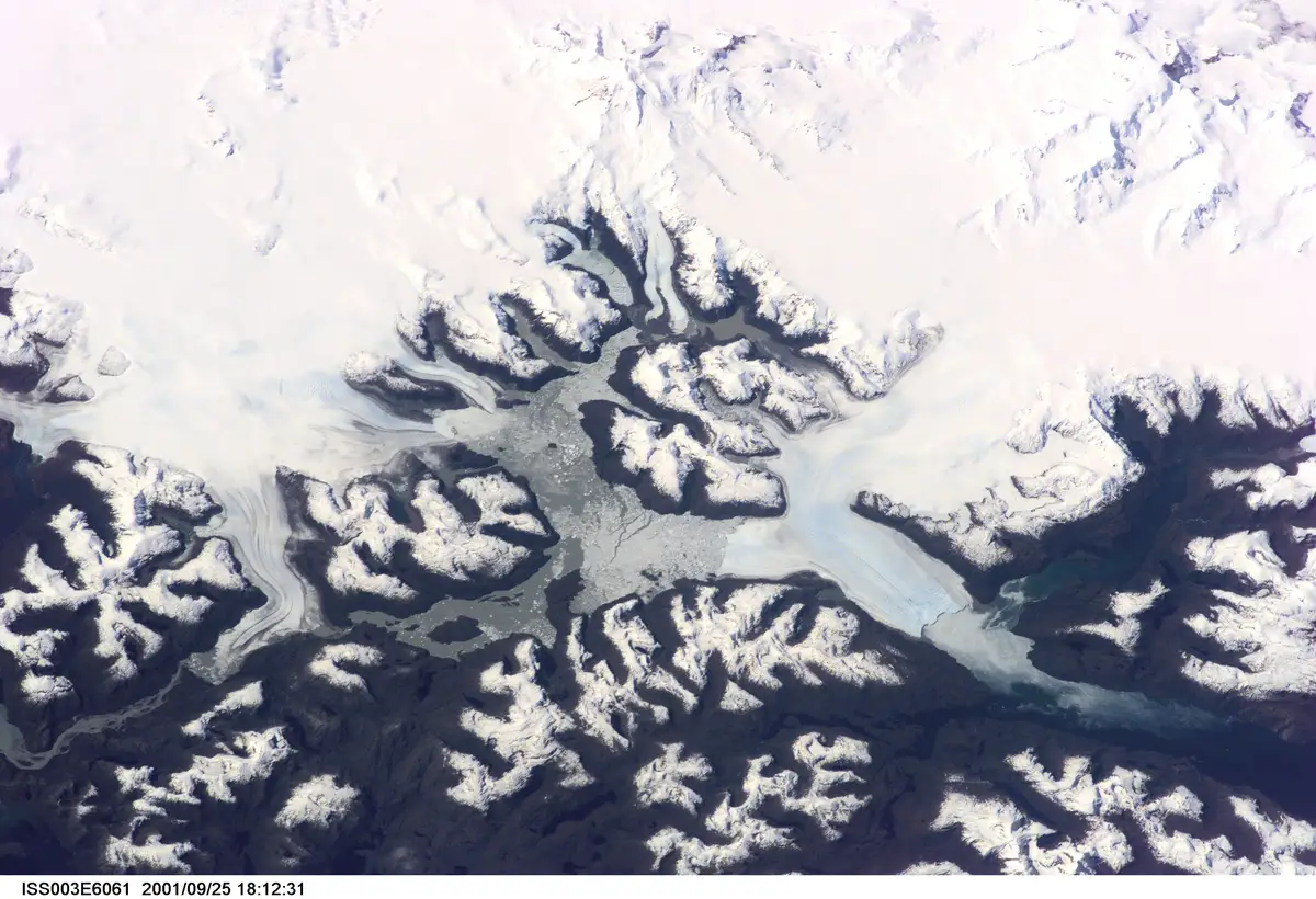
Pío XI Glacier, in our Magallanes Region, is the longest glacier in the southern hemisphere outside Antarctica, and it has a habit few people would expect from a glacier: it advances. This is not a figure of speech. The European Space Agency (ESA) recorded it from orbit, and Copernicus, the European Union's Earth observation programme, measured it again with an image taken on December 25, 2024: that day, Pío XI covered 126 km² more than it did in 1945. Among the glaciers of Chile, this is the one that breaks the mold. It moves against the general trend, and it has the paperwork to prove it.
The scale of the record makes sense once you see where it comes from. Pío XI flows down from the Southern Patagonian Icefield (Campo de Hielo Sur), which together with the Northern Patagonian Icefield (Campo de Hielo Norte) forms the Patagonian Icefields: about 16,500 km² of ice, roughly 4,000 in the north and 12,500 in the south, according to a 2022 study by Gómez and colleagues in Scientific Reports, which describes them as the largest non-polar ice mass in the southern hemisphere. Non-polar means temperate ice, kept close to its melting point, unlike the ice of Antarctica or Greenland, which sits far below zero. The volume says even more. In 2019, a team at the University of California, Irvine calculated that the two icefields hold roughly 40 times the ice of all the glaciers in the European Alps. Most of that ice lies in Chilean territory.
40x the ice volume of the Northern and Southern Patagonian Icefields compared with all the glaciers of the European Alps (4,756 km³ across both icefields)
Source: UC Irvine (2019), on Millan et al., Geophysical Research Letters (2019)
Forty times. The comparison is not ours: it comes from the study's own authors, Millan and colleagues, writing in Geophysical Research Letters, who estimated 4,756 cubic kilometres of ice for the two icefields. A cubic kilometre is a block of ice a thousand metres on each side, and here there are thousands of them. Same unit on both sides of the scale, ice against ice, no conversions and no tricks. That is why the record can be stated in full: the largest ice fields in the Southern Hemisphere outside Antarctica, as the university puts it. That landscape is also a big part of what makes our adventure tourism one of the best in the world.
Pío XI Is Growing: 126 km² More Than in 1945
First, the measurements. Pío XI, also known as Brüggen Glacier, is about 70 kilometres long and covered 1,255 km² in 2018, according to the study that glaciologists Hata and Sugiyama, from Hokkaido University, published in 2021 in Frontiers in Earth Science. The same paper calls it the largest glacier in South America. The words matter here: largest refers to area, longest to length. If it is the longest in the southern hemisphere outside Antarctica, as ESA states, it is also the longest in South America. Our Pío XI holds both titles on its continent.
Now, the strange part. ESA documented that its front, the edge where the ice tongue ends, first reached the western shore in the 1960s and has kept pushing north and south ever since. Between 2000 and 2018, the southern front advanced 1,400 metres. The glacier did not just grow forward: it also gained height. Hata and Sugiyama measured its surface elevation and found it rose an average of 37.3 metres over those eighteen years, at 2.09 metres per year, a pace that picked up to 2.69 metres a year between 2007 and 2017-2018. A glacier that thickens year after year, measured down to the decimetre.
"One of the most rapidly thickening glaciers in the world": that is how Hata and Sugiyama describe Pío XI in Frontiers in Earth Science.
The obvious question is how so much ice gets made at this latitude. Part of the answer falls from the sky. According to NASA's Earth Observatory, between 2 and 11 metres of precipitation fall on the Southern Patagonian Icefield every year. A glacier is, at heart, accumulated snow that compacts layer upon layer until it turns into ice and then flows downhill under its own weight. Where that much water falls from the sky, raw material is never short. Pío XI has plenty to feed on, and it makes the most of it.
Its growth story can be followed through four moments, measured by different institutions with different instruments. They are worth reading in order, because each one adds a layer to the one before.
- 1945Reference year for the Copernicus measurement: Pío XI's area in 1945 is the starting point against which its growth is measured.
- 1960sThe glacier front reaches the western shore for the first time and keeps advancing north and south from there (ESA).
- 2000-2018The glacier surface rises 37.3 metres on average and its southern front advances 1,400 metres (Hata and Sugiyama, 2021).
- December 2024A Sentinel-2 satellite image shows 126 km² more area than in 1945: 11% growth (Copernicus, published January 16, 2025).
Source: ESA (2016); Hata and Sugiyama, Frontiers in Earth Science (2021); Copernicus (January 16, 2025)
Read end to end, the four milestones show something no single photo can: the advance is not a seasonal accident. It became visible some sixty years ago, was measured to the metre early this century, and the latest image confirms it with a clean figure. Eleven percent more area than in 1945, which on the ground means 126 km² of new ice. ESA, Hokkaido University and Copernicus reach the same conclusion along independent paths, with different satellites and methods. Three sources in agreement. That is no longer an anecdote. It is a pattern.
San Rafael, the Tidewater Glacier Closest to the Equator
Further north, in Aysén, lies the other great system: the Northern Patagonian Icefield, about 4,000 km² according to Gómez and colleagues. Thirty outlet glaciers flow from it, according to the U.S. Geological Survey (USGS). An outlet glacier is a tongue of ice that breaks away from the main field and descends toward a valley, a lake or the sea, like a frozen river draining an entire basin. It is the same region crossed by the Carretera Austral, Chile's longest scenic route, where the landscape stops being a postcard and becomes sheer scale.
One of those thirty is San Rafael, and its record carries no hemispheric qualifier: it is global. It is a tidewater glacier, meaning one that ends directly in the sea and sheds blocks of ice into the water. The USGS describes it in its Professional Paper 1386-I, from 1999, as the lowest latitude tidewater glacier in the world. It sits at 46° south. In plain terms: there is no other place on the planet where a glacier touches the ocean this close to the equator. Every other tidewater glacier lies closer to the poles. Ours reaches the sea where no other one does.
Set against every other tidewater glacier on the planet, the record comes down to a yes-or-no answer.
- San Rafael Glacier (Aysén): the lowest-latitude tidewater glacier in the world46° S (Flows from the Northern Patagonian Icefield)
- Any other tidewater glacier in the worldNo (All reach the sea closer to the poles)
Source: USGS, Professional Paper 1386-I (1999)
Forty-six degrees. With San Rafael in Aysén and Pío XI in Magallanes, our two record-holding glaciers are entirely Chilean: one holds the world record and flows from the Northern Patagonian Icefield; the other is the longest glacier in the southern hemisphere outside Antarctica. Behind Pío XI lies the Southern Patagonian Icefield, the largest mass in the system, at about 12,500 km². Anyone who wants to see both records has to travel our Patagonia from end to end: one meets the sea in Aysén, the other advances in Magallanes.
For a long time this ice was known from the outside, but not how much of it there was inside. That changed in 2019. Millan's team, with the participation of Chile's Centro de Estudios Científicos (CECs) and the University of Bergen, produced the first complete measurement of the thickness of both icefields, combining radar with airborne gravimetry from NASA's Operation IceBridge mission. Gravimetry means recording tiny variations in gravity from an aircraft to work out how much mass lies beneath the surface. The result: ice more than 1,400 metres thick, and sectors where the bedrock sits below sea level. A mountain of ice resting on ground that lies lower than the ocean.
All this ice also has someone looking after it. Bernardo O'Higgins National Park, managed by CONAF, Chile's national forest and parks service, covers 3,525,901 hectares of land and includes all the Chilean territory of the Southern Patagonian Icefield, according to a study published in 2018 in the journal Magallania, from the University of Magallanes. The largest piece of our Patagonian ice is under State protection, whole, with no gaps. Science measures, the park protects, and both happen on the same ground.
Put the pieces together. A glacier that grows when nobody expects it, another that meets the sea where no other glacier on Earth does, a survey that reached the bottom of the ice with Chilean participation, and a national park protecting all the Chilean territory of the Southern Patagonian Icefield. Geography supplied the ice; science and the State took care of measuring it and protecting it. The same country that looks after the Atacama Desert sky that world astronomy relies on looks after its ice at the other end of the map. In Chile we have a word for a story like this: bacán, the Chilean word for something that earns your admiration. And when the data speaks this clearly, there is only one thing left to say: we are bacán.
Sources
Every fact in this article is backed by the following sources.
- Transient ice loss in the Patagonia Icefields during the 2015-2016 El Niño event
- Southern Patagonia Ice Field (ISS038-E-47324)
- Pio XI Glacier, Chile
- The advancing Pio XI glacier, Chile
- Changes in the Ice-Front Position and Surface Elevation of Glaciar Pío XI, an Advancing Calving Glacier in the Southern Patagonia Icefield, From 2000-2018
- Ice Thickness and Bed Elevation of the Northern and Southern Patagonian Icefields
- Patagonia ice sheets thicker than previously thought, study finds
- USGS Professional Paper 1386-I, Chile and Argentina - Wet Andes: Northern Patagonian Andes
- Parque Nacional Bernardo O'Higgins / Territorio Kawésqar Waes: conservación y gestión en un territorio ancestral